Local Geology

From greenhouse to icehouse
For nearly 2 million years the world has been in an ice age, with a series of long cold glacial periods and short milder (interglacial) interludes. Our present temperate period, which began about 11,000 years ago, is the Flandrian interglacial, though some climatologists believe it marks the end of the ice age, and the extent to which human activity is contributing to, or causing the current warming and associated sea level rise is subject of much debate. However climate change over geological time is a natural part of Earth’s interacting dynamic systems, and Hertfordshire geology tells us that south east England has spent more of the past 150 million years below the sea than above it, and in much warmer temperatures than at present.
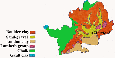
About 150 million years ago the Gault Clay was deposited in a delta environment when world sea levels were rising. The British Isles were at similar latitude to Italy today, and as part of the Eurasian plate have been slowly moving north.
About 80 million years ago during a time of exceptionally high world temperatures and sea levels (the Cretaceous Greenhouse) most of the British Isles was covered by a warm clear sea in which the Chalk was deposited, then later flints were formed chemically within the Chalk.
About 65 million years ago world sea levels fell and S.E. England was lifted up out of the sea and tilted south east by earth movements. Rivers washed the soft chalk away leaving the hard flints.
Sea levels rose again, and between about 60 and 55 million years ago the fluctuating coastline sometimes went through Hertfordshire. During sea level advances and retreats the Lambeth Group were deposited and it is in these deposits we believe
Hertfordshire Puddingstone formed.
About 54 million years ago S.E. England was beneath a shallow sea in a similar climate to the tropics today. Rivers flowing into this sea deposited the London Clay.

About 30 million years ago the climate began to cool towards the onset of the ice age about 1.75 million years ago, when sea levels fell as glaciers locked up water. River gravels were deposited by the Proto-Thames which flowed through the Vale of St Albans to the North Sea until about 450,000 years ago when ice of the Anglian glaciation advanced, at times reaching as far as North London, covering Hertfordshire in ice (estimated as up to1000 meters thick) and diverting The Thames to its present course. The glaciation has left its marks, including boulder clay, sand and gravel deposited during periodic advance and retreat of the ice sheet, and river terraces formed by successive downcutting as sea level fell.